Martographers
Mars' leader in Global Positioning
"If you're on Mars, we'll find you!"
Orbital Mechanics
Kepler's Laws and some geometry
In order for satellites to be able to ensure their location, their orbits consistently return them to the same position relative to Mars every Martian day (1.027 x Earth's sidereal day). Two options are to have an orbital period of one Martian day or 1/2 of a Martian day. In order to make the link budget more effective, the final decision was to utilize the half day period (44,245 seconds). Using Kepler's third law of planetary motion, the resulting radius of the orbiting satellites can be attained:

P= period, μ = gravitational constant (42,848 km3s-2)
Therefore, the satellite radius = 12,856 km, and the altitude becomes 9,460 km (Mars' radius is 3,396 km). With the known radius of the satellites, the nadir angle can be determined, which is half of the beamwidth necessary to cover the maximum area of the planet, and is dependent on the minimum allowable elevation angle (elevation mask). In the case of the NAVSTAR system, this is set to 15 degrees in order to avoid having signals sent through greater lengths of the ionosphere and troposphere, where they are more apt to incur pseudorange errors due to the delays induced by these layers of the atmosphere.[1]
In the case of Mars, however, the atmosphere is much thinner than that of Earth, and with the lack of buildings and trees that would cause multipath errors, the elevation mask can be ignored (θ = 0 degrees).[2]

Fig 1: Satellite field of view geometry [3]
α = nadir angle = 15.32 degrees
β = central angle = 74.68 degrees
θ = elevation angle = 0 degrees
s = slant range = 12,399 km
rsat = geocentric radius of satellite = rm + hsat =12,856 km
rm = radius of Mars = 3,396 km
The next objective was to determine the most efficient way of organizing these satellites so that every point on Mars has at least four satellites in view at all times.
The current Earth model (NAVSTAR) uses six constellations of four satellites inclined at a 55 degree angle with a period of half a sidereal day. Obviously replicating this system would yield desirable results, however the NAVSTAR system typically has at least seven satellites covering most points, and the Martian system requires just four. Using STK, software developed by Analytical Graphics Inc., satellite orbits around Mars can be simulated and tested to determine their coverage on the surface of the planet.[4]
The inclination of the NAVSTAR system was not designed to be as accurate at the poles as it is over the United States, but for the Martian system, there is no more or less important region, and therefore the inclination angle is at 60 degrees in order to more adequately cover the entire planet.
The minimum number of satellites that can cover Mars based on the given criteria was determined to be 15 (five constellations of 3 satellites). Each constellation is inclined at 60 degrees and separated from neighboring constellations by 72 degrees RAAN (right ascension of ascending node). Each constellation has the three satellites spaced out evenly (changes in epoch = 08:12:00 UTC). Below are screenshots from the STK simulations that show the paths across Mars that the satellites take:

Fig 2: Single constellation of three satellites: Click to view larger

Fig 3: Five constellations (15 total satellites) Click to view larger
In order to test the coverage of these orbits, STK allows users to take reading of the number of visible satellites from individual points, or a set of points. Points were placed over the entire planet with a resolution of 6 degrees, and the simulation was run for a Martian day. The resulting report determined the percentage of the time that all 1,148 points could receive a signal from at least four satellites. The constellation setup described achieved 100% coverage at all times.
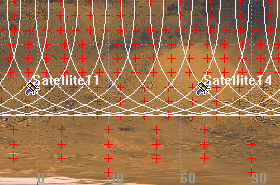
Fig 4: Zoomed in view of the STK coverage tool. Each + represents a point on the planet that determines if at least four satellites are in view.
For orbital correction, see Propulsion System
References:
[1]: NAVSTAR GPS User Equipment Introduction. United States. U.S. Coast Guard. Navigation Center. Sept. 1996. 4 Dec. 2008 <http://www.navcen.uscg.gov/pubs/gps/gpsuser/gpsuser.pdf>.
[2]: Seiff, Alvin, and Donn B. Kirk. "Structure of the Atmosphere of Mars in Summer at Mid-Latitudes." Journal of Geophysical Research 82 (1977): 4364-378.
[3]: Eagle, C. David. "Coverage Characteristics of Earth Satellites." Orbital and Celestial Mechanics Website. 2 Dec. 2008 <http://www.cdeagle.com/html/ommatlab.html>.
[4]: Satellite Tool Kit. Vers. 8. Computer software. Analytical Graphics Inc. 2008. 2 Dec. 2008 <http://www.agi.com>.